Data Center Site Selection Criteria: A Practical Framework
Master data center site selection criteria with a practical framework covering power, connectivity, water risk, zoning, and community impact for modern builds.
16 min read
The most popular advice on data center site selection criteria starts with a familiar checklist: power, land, fiber, water, permitting, labor, and risk. That list is useful only after a more basic question has been answered: can the site become energized, entitled, connected, and expandable within the project's financing window?
In 2026, a cheap parcel with uncertain grid access can be less valuable than a smaller site with a credible path to power. Modern developers increasingly screen for time-to-power and buildability first, then assess the softer advantages of geography, taxes, and market proximity. The distinction matters across established clusters such as Northern Virginia, Dublin, and Frankfurt, where capacity may exist in principle while transmission, substation, planning, or community constraints determine whether a campus can proceed.
Table of Contents
- Why Traditional Site Selection Frameworks Are Failing
- Power Availability and Time-to-Power as the Dominant Constraint
- Network Connectivity and Fiber Diversity Requirements
- Real Estate, Zoning, and Water Risk as Buildability Filters
- Risk Profiles, Cost, and Community Impact Considerations
- A Practical Decision Framework for Site Selection
Why Traditional Site Selection Frameworks Are Failing
A site can win a scorecard and still fail in development. The current market separates location criteria into two groups: preferences that improve a project, and hard gates that determine whether construction can proceed. Time-to-power and physical buildability now belong in the second group.
Earlier siting research treated location as a structured optimization problem across geographical, financial, political, social, and technical categories. A 2012 multi-criteria study identified those five top-level dimensions. Its low-carbon model assigned 28% to infrastructure, 23% to natural geographical resources, 20% to cost, 16% to neighboring risk, and 13% to local policy and human resources, as documented in the Purdue-hosted siting study.
Those figures are useful historical evidence, not a current approval formula. A parcel may perform well on land cost, geography, and political fit while failing the condition that makes the project financeable: deliverable electrical capacity on a usable schedule. In practice, the first screen should test whether the site can become energized and physically developed, rather than allowing favorable secondary attributes to offset an unresolved grid constraint.
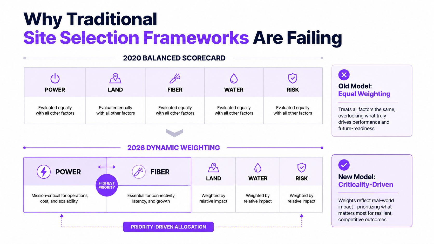
The old model asks which site has the highest aggregate score. A better model asks which candidates survive sequential elimination.
The false positive created by cheap land
Cheap land is a particularly persuasive false positive. It is visible, negotiable, and easy to compare. Grid capacity is less visible, while utility studies may depend on conditional assumptions about upgrades, queue position, transformer availability, and future transmission work. Teams can therefore commit capital and attention to a parcel before the utility has established a credible energization path.
Industry guidance identifies reliable power as the primary site selection factor, with interconnection timelines in constrained markets potentially reaching three to five years. A technically suitable parcel may still be commercially unusable if customer demand, financing, or equipment procurement follows a shorter schedule.
Practical rule: A site should not receive a positive score until its power path has a credible date, scope, and responsible utility contact.
Land, fiber, water, and risk still matter. Their position in the process changes. Developers should verify the utility territory, points of interconnection, deliverable capacity, and major physical constraints before signing land control. A structured market directory such as Data Centers List can provide local context, show visible facilities, and indicate whether a candidate area sits within an established or emerging cluster. It cannot replace utility diligence.
The strongest pipeline process acts less like a balanced matrix and more like a funnel. Power timing eliminates candidates first. Buildability eliminates the next group. Cost, community impact, labor, and long-term risk then distinguish the sites that remain.
Power Availability and Time-to-Power as the Dominant Constraint
A utility may confirm that a region can eventually support a large load, yet the site can still fail because the required substation, transmission upgrade, transformer, or study sequence will not align with the development schedule. Cheap land with uncertain grid timing is one of the most common failure modes in hyperscale and AI campus pipelines.
The relevant measure is deliverable MW by a defined energization date, not nominal capacity shown on a planning map. A credible review separates existing firm service from proposed upgrades, identifies open milestones, and distinguishes a signed interconnection agreement from physical energization. Energization still requires construction, testing, approvals, and operating readiness.
A site can therefore look inexpensive while carrying an unpriced schedule risk. If the utility cannot identify the work, sequence, and accountable parties needed to deliver power, the parcel is not ready for a positive investment decision.
Read the grid map as a schedule
Screening should begin with utility service territories and target interconnection points. Teams can then filter parcels by zoning, land area, and buildable acreage. This order reflects current hyperscale guidance, which recommends identifying the power system first and removing wetlands, slopes, flood zones, wildfire exposure, and other hazards before treating a parcel as developable (hyperscale site selection guidance).
Distance matters because the connection itself becomes part of the project. Sites close to high-voltage substations have a material advantage. Industry guidance identifies one to three miles as a particularly advantageous range, while sites beyond five miles may require expensive dedicated transmission construction. The practical lesson is direct: a large parcel near a scalable substation can outperform a larger, cheaper parcel separated from the grid by difficult rights of way or limited transmission capacity.
The review should ask:
- What capacity is firm? Separate currently deliverable service from theoretical regional capacity.
- What upgrades are required? Identify substation expansion, transmission reinforcement, protection changes, and customer-funded works.
- Which queue milestones remain? Record study status, approvals, equipment procurement, construction, testing, and energization.
- Can power arrive in phases? A phased agreement may support an initial building while later capacity remains conditional.
- What bridges the gap? On-site or behind-the-meter generation can support schedule strategy, but it does not remove the need for durable grid service, fuel logistics, emissions compliance, or long-term redundancy.
Compare site profiles without hiding uncertainty
The table below is a qualitative screening tool. It avoids treating nominal utility capacity as proof of deliverable service.
| Site Profile | Distance to Substation | Nominal Capacity | Deliverable MW (N-1) | Estimated Queue Timeline | Viability Rating |
|---|---|---|---|---|---|
| Energized industrial campus | Close to existing substation | Documented local capacity | Confirmed after contingency review | Shorter, subject to final approvals | High, if expansion is verified |
| Adjacent greenfield parcel | Within the advantageous range identified in industry guidance | Available in principle | Requires utility confirmation | May be manageable, but upgrade scope controls | Conditional |
| Remote large parcel | Beyond practical substation adjacency | Appears substantial on regional maps | Unclear until transmission studies finish | Potentially extended | Low until the utility validates the path |
| Constrained urban parcel | Close to network demand but limited grid headroom | Restricted or competing load | May be lower than the headline figure | Queue and reinforcement dependent | Conditional to low |
| Phased campus with bridge generation | Grid service supplemented during development | Mixed sources | Depends on firm grid commitment and operating permits | Can improve early deployment, not necessarily final delivery | Project-specific |
The most important distinction is between queue time and energization time. A study milestone can show progress without proving that the facility will receive power. Financing committees should require a dated schedule that names utility deliverables, customer obligations, dependencies, and fallback measures.
Current industry coverage frames time-to-power as the decisive constraint for AI and hyperscale development. In saturated markets such as Northern Virginia, London, Amsterdam, and Frankfurt, formal capacity on paper may not equal usable near-term supply because transmission and substation constraints limit what can be delivered (global data center pipeline coverage). The first investment in a candidate site should often be utility diligence, not architectural design.
Network Connectivity and Fiber Diversity Requirements
Fiber near a parcel is not the same as usable connectivity. A route shown on a map may lack diverse entrances, available capacity, or a construction path that can be permitted on schedule. Last-mile work can involve several jurisdictions, road crossings, easements, railways, waterways, and separate property-owner approvals. Those dependencies can delay deployment even when a backbone appears adjacent.
The evaluation should therefore measure time-to-connect, not carrier proximity. Require written confirmation of route ownership, available capacity, points of entry, construction scope, and each party's responsibility for permits and restoration. A candidate site that reaches power quickly but needs an unplanned lateral build can still miss the campus deployment window.
Test adjacency, not marketing distance
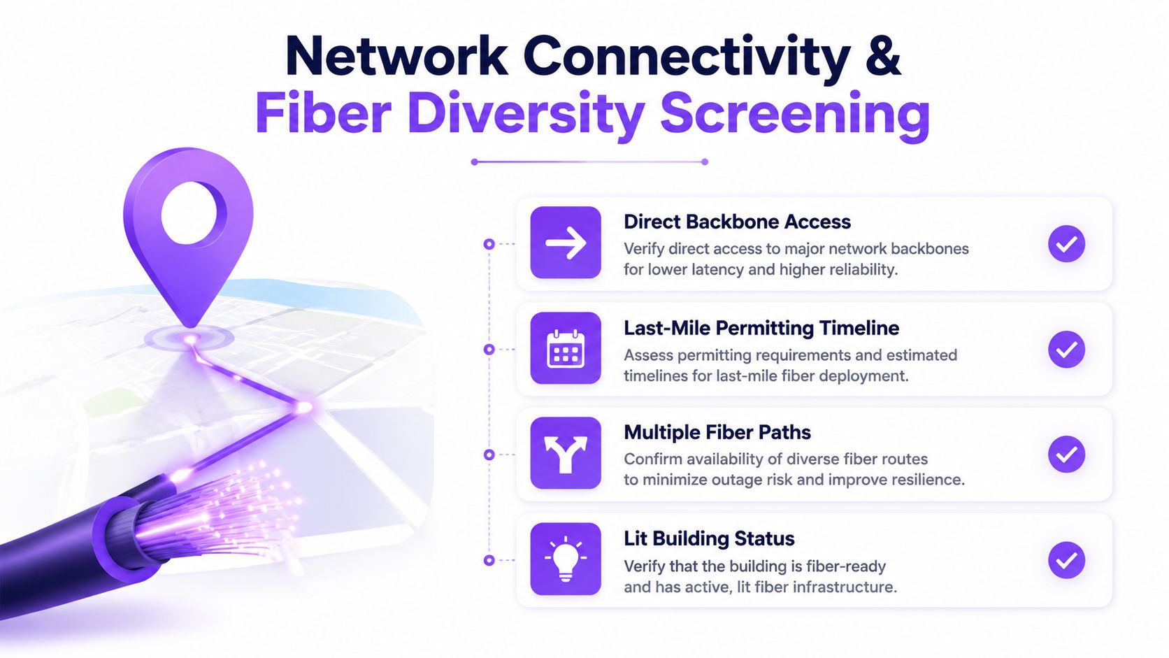
A defensible fiber screen verifies four separate conditions:
- Direct backbone access: Establish whether a route reaches the parcel or ends nearby. A mapped line has limited value without a buildable entrance path.
- Last-mile permitting: Identify every jurisdiction, road crossing, railway, waterway, private easement, and approval required for the lateral build.
- Multiple physical paths: Trace routes to confirm that supposedly diverse entrances do not converge in one conduit, bridge crossing, duct bank, or carrier hotel.
- Lit-building status: Separate an operating facility with established interconnection from a site that merely sits near carrier infrastructure.
The physical route matters more than the provider count. Several carriers may share one trench, while fewer providers can offer stronger resilience if their paths enter from separate directions. Request route drawings, entry points, meet-me room arrangements, restoration procedures, maintenance boundaries, and construction responsibilities. A carrier availability statement alone does not establish deliverability.
Match network design to workload
AI training, inference, cloud services, enterprise applications, and edge workloads create different requirements. A training campus may prioritize high-capacity inter-site links and route diversity. An enterprise-focused site may place more weight on customer latency, cloud on-ramps, and exchange access.
Dark fiber, leased wavelengths, and lit services also create different operating obligations. Dark fiber provides greater control over equipment and upgrade paths, but the operator assumes more network responsibility. Leased capacity can shorten deployment, while contract terms, service levels, and restoration procedures require close review.
A documented facility profile, such as the Hurricane Electric Fremont 2 facility profile, illustrates the facility-level context useful for market and connectivity research. It does not prove equivalent access for nearby parcels. Route-level verification remains required, particularly where fiber construction could become the gating item after the site has already cleared land and power screening.
Real Estate, Zoning, and Water Risk as Buildability Filters
Cheap land is often the least reliable indicator of a viable data center site. A parcel can offer ample acreage and still fail because ownership is fragmented, access depends on an unresolved easement, the master plan conflicts with the proposed use, or water service cannot be secured under enforceable terms. These constraints can add more time than the land savings justify.
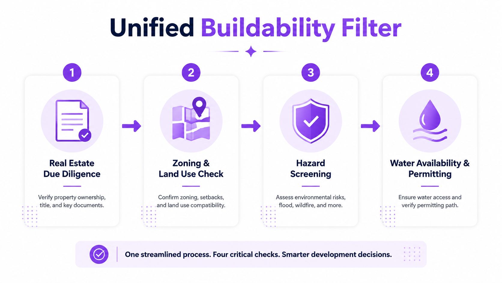
Real estate, zoning, hazards, and water should therefore operate as a unified buildability filter. Run the checks concurrently with power and network diligence. A site that clears zoning but cannot obtain water permits remains nonviable, just as a site with available land but no credible path to energization cannot support a construction schedule.
Establish control before the option becomes expensive
Real estate diligence must cover the full development footprint, not only the advertised parcel. The review should include:
- Ownership structure: Identify every parcel, owner, lien, easement, and access dependency.
- Assemblage exposure: Determine whether the campus requires multiple acquisitions, leases, or rights of way.
- Buildable acreage: Exclude setbacks, wetlands, slopes, flood areas, stormwater requirements, and infrastructure corridors before calculating usable land.
- Expansion continuity: Test whether later phases can remain within the same entitlement and utility strategy.
- Construction logistics: Confirm road strength, heavy-equipment access, staging space, turning movements, and delivery constraints.
Gross acreage can differ materially from the area available for buildings, substations, cooling equipment, security setbacks, and stormwater systems. Land control should be based on the constrained development envelope, not the seller's headline figure. If the footprint depends on several owners or an access right that has not been documented, the schedule carries a structural risk before design begins.
Treat zoning as an execution question
A zoning label does not establish a permit path. Review plan alignment, special-use approval requirements, noise rules, height and setback limits, environmental review, and the jurisdiction's record of approving comparable infrastructure.
Local planning capacity can become a schedule gate even when elected officials support the project. Identify decision makers, hearing requirements, technical studies, appeal rights, and likely conditions before assuming a permit date. Community acceptance, transportation impacts, visual screening, and utility infrastructure can shape entitlement timing as much as the underlying designation.
Make water a legal and operational test
Water risk is a buildability issue, not only a sustainability metric. The review should establish whether the asset can secure a legal, dependable supply across its operating life:
- Source authority: Is the source permitted for the intended use?
- Demand profile: What volume is required for initial fill, and what volume represents recurring make-up demand?
- Drought priority: How does the facility rank against municipal, agricultural, and other users during curtailment?
- Reclaimed supply: Are recycled-water obligations available and enforceable, or merely proposed?
- Discharge capacity: Can wastewater infrastructure accept the expected flow and quality?
- Cooling alternatives: Can reduced-water or waterless systems meet density and reliability requirements?
Analysis of water and interconnection risk places water permitting alongside interconnection risk, particularly for cooling-intensive AI facilities. The decision standard is whether the site can legally and reliably secure water through a drought cycle. A municipal line shown on a map does not establish that outcome.
Risk Profiles, Cost, and Community Impact Considerations
A technically feasible site can still fail because its approval path, labor market, or delivery cost was assessed too late. Compare risk, community impact, labor, policy, and total cost of ownership while screening sites, alongside power timing and physical buildability. Cheap land has little value if public objections, insurance requirements, or utility work extend the schedule beyond the project's financing window.
Natural hazard analysis should examine exposure and recovery conditions, not rely on an inside-or-outside map designation. Flooding, wildfire, severe weather, seismic conditions, emergency access, insurance requirements, and business continuity design shape the long-term risk profile. A parcel outside a mapped hazard area may still depend on vulnerable roads, regional utilities, or disrupted emergency routes.
Compare markets by execution environment
The table below is qualitative. Market conditions support targeted diligence, not a universal ranking across these categories.
| Market | Natural Disaster Risk | Labor Competition | Community Opposition Risk | Tax Incentive Strength |
|---|---|---|---|---|
| Northern Virginia | Requires detailed flood, storm, and grid-resilience review | Competition can be significant within a mature cluster | Scrutiny may focus on power, land use, noise, and community impacts | Must be verified against current local policy |
| Dublin | Requires local climate, grid, and infrastructure review | Workforce depth and competition need project-specific testing | Planning and resource concerns can influence approvals | Depends on applicable national and local measures |
| Frankfurt | Requires site-specific hazard and infrastructure review | Skilled labor availability should be tested against regional demand | Noise, land use, and energy concerns can affect acceptance | Must be confirmed through current jurisdictional analysis |
| Amsterdam | Requires careful review of environmental and utility constraints | Staffing access may compete with established digital infrastructure | Expansion and resource impacts may receive scrutiny | Requires current policy and project eligibility review |
Labor analysis must cover construction and operations. A region may offer experienced contractors but too few long-term technicians. The reverse also occurs, with a strong technical workforce competing for staff across nearby facilities. Staffing plans should test shift coverage, maintenance vendors, emergency response, and training pipelines before land control becomes difficult to unwind.
Price the approval path, not only the parcel
Total cost of ownership includes land, utility extensions, substations, transmission work, impact fees, taxes, water infrastructure, environmental mitigation, security, labor, and expansion. A low acquisition price can disappear within a difficult interconnection or entitlement package. Cost models should also separate committed expenses from allowances, because unresolved utility and permitting scope can make an apparently cheap site impossible to compare fairly.
Community impact requires early treatment. Noise ordinances, visual screening, traffic, tax arrangements, water use, and sustainability commitments can affect approval speed and operating legitimacy. Warning indicators include unresolved community concerns, unclear noise standards, repeated requests for additional studies, strained municipal infrastructure, and a public process without a credible route to decision.
A site with no social license carries schedule risk even when the engineering package is sound.
The strongest comparison asks which market can support reliable operation, permitting certainty, workforce access, public acceptance, and expansion without requiring a campus redesign after land control. That test links community acceptance to delivery economics. A site that appears inexpensive on acquisition may carry the highest total cost when approval uncertainty and delayed power are included.
A Practical Decision Framework for Site Selection
A site should not advance because its land is cheap or its map location is attractive. The decision framework starts with hard gates, then scores only the candidates that pass them. Weighted averages cannot rescue a parcel without a credible power path, lawful construction route, cooling capacity, or network access.
Phase one verifies the infrastructure path
The first screen should establish:
- Power: utility territory, interconnection point, deliverable capacity, upgrade scope, queue position, and a credible energization sequence.
- Fiber: physically diverse routes, entrance options, carrier access, lateral construction, and the likely permitting path.
- Basic buildability: gross acreage, usable land, access, hazards, grading constraints, and expansion geometry.
The sequence matters. Eliminate candidates when they fail a required infrastructure condition. Do not retain them because acquisition cost or regional location appears favorable. A cheap parcel with an undefined grid schedule is not an inexpensive project. It is an unpriced delay.
Phase two tests entitlement and resource security
Candidates that pass the infrastructure screen require parallel review of zoning, master plan alignment, special-use approvals, environmental constraints, water rights, wastewater capacity, parcel control, and construction logistics.
Each item needs a documented go or no-go finding. “Under discussion” is not approval. It is an unresolved dependency that belongs in the risk register, financing schedule, and delivery plan.
Phase three models economics and execution risk
Only then should the team build a detailed cost and risk model covering:
- Utility exposure: customer-funded upgrades, escalation risk, and bridge-power requirements.
- Approval exposure: studies, hearings, mitigation, appeals, and approval conditions.
- Site exposure: assemblage, easements, access, hazards, grading, and stormwater.
- Operating exposure: water, cooling, taxes, labor, insurance, and resilience.
- Expansion exposure: future land, power blocks, fiber, and entitlement flexibility.
The weighting should reflect the workload and business strategy. AI training, enterprise colocation, edge deployments, and hyperscale campuses place different values on latency, water, expansion, and customer proximity. A single score can hide that difference, so the model should show which gate or assumption drives the result.
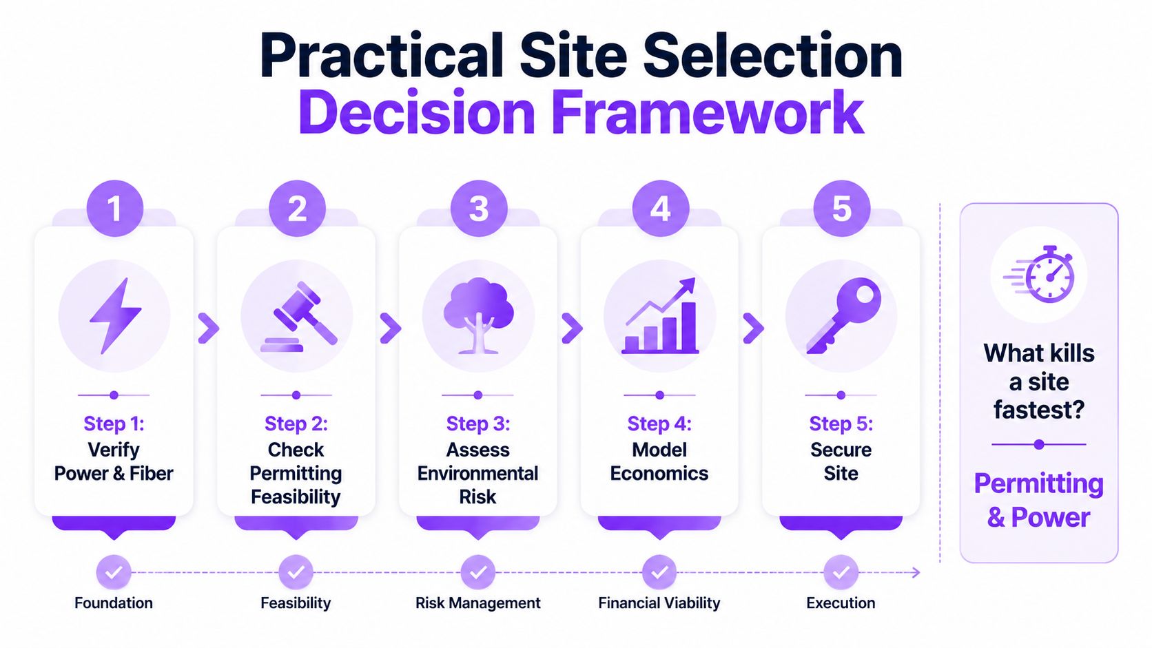
Site control comes after evidence. A searchable data center directory for market mapping can organize candidates by location, operator, status, and reported or estimated IT power. Planning records, utility correspondence, and site investigations must validate the development case.
Decision standard: The winning site has the clearest path to usable capacity, lawful construction, resilient operations, and phased expansion.
Data Centers List provides a global directory and interactive map covering active, planned, and under-construction data centers. Its facility context includes operator, market, status, and disclosed or labeled AI-estimated IT power. Teams assessing data center site selection criteria can use Data Centers List to compare candidate markets and review pipeline visibility before deeper utility and permitting diligence.